SNIPPETS
LETTERS
GPS12XL Update 7 - Wookey
Update on last issues first impressions of the GPS12XL,
now that it has been used for a lot of driving around.
Field Meet, July 1997, Yorkshire - Wookey & Pete
Grant
Report of the field meet and what went on - Blitz
surveying in Lost John's, Helmet-mounted laser surveyor, and bits
on instruments and computing.
12th UIS Congress - Surveying report - Wookey
Report of the parts of the congress relevant to surveying,
including the post-congress Cave Surveying & Computing Workshop.
Survey software, Symbols discussion, survey competitions, Drawing
techniques, international surveying variations, cave data-model
discussion.
CSG Constitution - Andy Atkinson
All the tedious details of how the CSG should be
run - published for your perusal before voting at the AGM.
It was mentionned at the field meet that Compass Points is very biased towards computing and software as opposed to actual surveying. As Editor I recognise that this is the case. In defence I can only say that it reflects my own interests, and I have written a lot of the articles. It is also the case that a lot of the current developments are in this area. Nevertheless I am very keen to try to reduce this bias and will try to publish more about the other aspects of surveying.
I have a couple of articles lined up, but beyond next issue it is up to all you surveyors to write something about your areas of interest, be it instruments, project surveying, drawing, station positioning, handy tools etc. Without a flow of material from you the readers, Compass Points will be much less interesting. I don't actually want to write it all you know!
The CSG well be holding its AGM at the BCRA conference in Bristol. (12th-14th September in case you didn't know) This will not be a particularly formal meeting, and we would like to see a few of you to check that CSG is meeting your needs. There are a number of things to discuss, and this is the opportunity to get your opinions heard with a minimum of effort.
Ratifying the Constitution: The CSG now has a formal constitution, incorporating the changes discussed at last year's BCRA conference, which should be officially Okayed. It is printed in this issue for you all to cut out and keep. Future new members will be sent one on joining.
Data Archiving discussion: The CSG wishes to follow the lead of various groups in other countries to maintain a central store of survey data, such that the data is protected according to the wishes of those who collected it, but will also not be accidentally lost. We would like a mandate from the membership to proceed with getting this off the ground.
Setting Prices for the coming year: A small change in the pricing is likely due to the increasing independence of the CSG from CREG. Electronic subscriptions will also be launched.
We have noticed over the last couple of months that a few subscriptions have got lost during the changes of administration that have occurred with the separating of CREG & CSG, and the change in CREG secretary. We apologise to those of you who paid money but didn't get paper though the door. I hope it is sorted out now, but if anyone knows of any further cock-ups then please tell the secretary and he'll sort it out.
Larry Fish
I would like to announce a new release of the cave survey software package COMPASS. Now that the process of porting COMPASS to Windows has been completed, I have finally been able to focus on adding new features. In this release I have tried to catch up on the many features that people have requested. I have also added lots of new features that I have been dreaming about over the last few years. There are more than 20 major new features and more than 100 minor changes. Here is a list of the most exciting new additions:
So that everyone can use the 3D mode, I have purchased a supply of inexpensive red-blue glasses. Anyone, who registers COMPASS will receive two free pair of glasses. Previously registered COMPASS users can purchase four pair for $5.00.
First of all, you can individually colour surveys, label stations for an individual survey, and mark cave and GIS features. For example, you could colour the "AB" survey blue, the "BD" survey red, exclude the "CDB" survey and label stations only in the "DXY" survey. Feature marking allows you mark any feature in a cave including things like leads, water, minerals, fossils, fauna etc. Each feature can be marked with a different symbol and colour. Features that have numerical values associated with them can be represented as symbols whose size varies according to the values. For example, you could mark a cave stream with symbols that get larger as the pH goes up.
Second, you have complete non-linear control over colouring based on the survey date or the passage depth. This means that each colour can be assigned a different, non-equal range of dates or depths. So, for example, you could colour all the surveys completed in the first 10 days of exploration in Lechuguilla Cave red, all the surveys in the last year of exploration green and the rest of the cave blue. As another example, you could use 10 different rainbow colours on the bottom 80 feet of Lechuguilla while colouring the rest of the cave red.
Third, you can exclude or clip off portions of the cave based on the survey name, survey date or position of the passage in the cave. Position clipping can be done using north, south, east, west, top and bottom clip lines.
All these options are very easy to setup. With the colouring, the range of date or depth values is displayed as column of colours called a "colour bar." You just drag the borders of the bands into the proper position. You can set any band to any colour and also copy colours between bands by dragging and dropping with the mouse. Finally, you can automatically create smooth colour gradients between any two colours. With the clipping, you just drag the clip lines into position over images of the cave. You can also set them to exact number values down to a tenth of a meter or foot.
I am very excited about my new version 5.0, which brings 3D modelling and quality animation to cave surveying. WinKarst allows the user to view their cave survey as modelled with its passage dimensions from any angle, spinning the view with the mouse. The rendering speed is on par with the best VRML viewers. As before, WinKarst is the only cave survey software which supports geographic co-ordinates of multiple caves in a system. In the pass three releases, WinKarst has been improved in over 60 ways.
This quarter's C&T is about 50% written by George Dasher, mostly about the Cartography Salon. He gives the results of the 1996 salon at Salida, Colorado, has a plea for salon judges who don't all come from the eastern US, the committee's judging criteria for the salon, and some thoughts about how the salon went in 1996.
The problem with Least Squares Loops Closures, by Larry Fish, as published in CP15.
Computer Graphics for Cave Maps, by David Parr. David is a professional technical illustrator, who had a computer forced upon him in 1991. He was initially very suspicious, but then found out all the ways it can make your life easier. B-splines, consistent line-weights, fill patterns, object grouping, libraries of frequently-used symbols, zooming & lettering. He has a word of warning about making your B-splines or fill-polygons too complex, or to try and do too long a cave in one document. One day it will blow up and lose an awful lot of work. He keeps to sheets of foolscap-sized paper
No Excuse for not knowing Magnetic Declination, by Bert Ashbrook. Bert points out the existence of a service to provide declination at the USGS in Denver. You can call them up and give your Lat./Long. And date and they give you the magnetic variation to the nearest tenth of a minute. If you ring up during the evening they will even ring you back. Interesting to see if this works from the UK!
Cartographer's Corner, Pat Kambesis. This time we have three examples of drawing primarily vertical caves. The first is by Nancy Pistole and is an elevation of a single 278m shaft with numerous stacked cross-sections down one side to show how the shape of the shaft changes. The second is another example of the same technique from Barb Luke. The third is from Peter Sprouse, and shows how to draw an overall schematic plan, then show each layer separately as you go down the elevation so that it makes sense.
Pete.Cousins
In compass points no 15, Larry Fish summarised the errors that might occur in a cave survey and posed the question 'is least squares the best method of loop closure?'. I would like to suggest that closure should normally be a two part process; only the second phase of which is based on a Least Squares (LSSE) algorithm.
The problem, as Larry clearly shows, is that LSSE is essentially a method for dealing with residual Random Errors. It will give a solution to adjust most other errors; but not necessarily the best solution. Indeed; as it always changes the measured lengths of individual survey legs; LSSE will often give a poor solution as, blunders apart, length measurements are the least likely source of significant errors.
There is one compass error to which all magnetic surveys are subject - declination. Although, in principle, this can be 'corrected'; unless the precision of this correction is better than that of the main survey there will always be a significant residual uncertainty in the bearings. Say, for example this is 0.5 degrees; that will result in an uncertainty of 8.8 metres per kilometre of straight passage; even in an otherwise perfect survey. The best solution is of course to increase the precision of calibration by averaging multiple bearings; but this may not always be practical. The second best solution is to revise the method of loop Closure to include a first phase where complete units of the survey (work from one survey trip with one compass) are 'swung' to give a 'nearest fit' before the traditional LSSE is invoked to finish the task.
Although the finished survey will often look the same; one side effect of this two phase closure will be better information from LSSE in phase II on the probable level of random errors and blunders in the survey as one source of systematic error should already have been minimised.
Note that the above discussion applies only to the Plan data of a magnetic Survey and we cannot correct the altitude misclosure in a 'Leap-Frog' type survey in the same way. The effect of clinometer miscalibration is fortunately minimised by 'leap-frog' working and significant residual errors in the elevation must usually be attributed to blunders.
P.R. Cousins.
Olly Betts replies:
Apart from transient disturbances in the Earth's magnetic field, the magnetic declination is probably best corrected for by using a value from some external source. However, Pete's argument is equally valid when applied to a compass which reads off by a fixed amount. It's not valid when dealing with an eccentric compass card though, since then the offset then depends on the value.
Pete asserts "[Least Squares] always changes the measured lengths of individual survey legs". This is certainly not true in general. If suitably applied, least squares is fully capable of taking into account differing accuracies for the measurements involved.
I'll use Survex to try an example of a compass with an uncorrected systematic error which adds a degree to every reading, on a simple survey round two sides of a 100m square. To emphasise that Survex doesn't put all the error on the tape as Pete asserts, I'll set the expected errors for the tape and position to very low values:
*sd tape 0.00000000001 metres
*sd position 0.00000000001 metres
*fix 1 0 0 0
1 2 100 001 0
2 3 100 091 0
*fix 3 100 100 0
With the current development version of Survex (used since it takes co-variances into account in the least squares calculations) this gives:
( 0.00, 0.00, 0.00 ) \1
( -0.01, 100.02, 0.00 ) \2
( 100.00, 100.00, 0.00 ) \3
which is equivalent (to 2 decimal places) to:
1 2 100.02 359.99 0
2 3 100.01 90.01 0
So the length has changed by only a centimetre or 2 in 100 metres, but the angles have changed by about 1 degree. In fact the answer Survex gives here is very close to what you'd expect - the differences are probably due to linearity approximations in the equations used (e.g. sin X X for small X).
It's possible Pete's assertion comes from looking at similar examples. A lot of cave surveying software falsely assumes the errors in x, y and z are independent when doing least squares, since it makes the equations rather easier. This doesn't mean least squares is flawed, rather that such software is. [Although if you try the above with the current release version of Survex (which doesn't have the co-variance code) then you still get very similar results to those above - Ed.]
I'll move on to addressing Pete's suggestion that each survey be "swung" to the best fit before applying least squares.
There's an issue here of what to do in an interconnected set of loops where multiple surveys will need to be swung and the best fit obtained for all. There will obviously need to be some compromise, and in fact least squares (applied in a slightly different way to how it's usually used in cave survey software) would be the best technique to use to balance the different swings.
Pete says: "one side effect of this two phase closure will be better information from LSSE in phase II on the probable level of random errors and blunders in the survey as one source of systematic error should already have been minimised."
The problem with this is that the misclosures due to any gross errors will be changed by swinging surveys. So in fact it will confuse a gross error detector which tries to guess which leg the error lies in by examining the misclosure vector.
The best approach is probably to combine a check for systematic compass errors into the software's gross error detection algorithm. A similar check for a systematic clino error could also be included, which would be useful for surveys which aren't leapfrogged.
Olly
Wookey
After 4000 miles of driving around Europe with the GPS on the dash I can give you a bit more info on how it works in practice.
I have to start by saying that a GPS is brilliant for driving around unfamiliar places. It makes it very obvious when you have gone the wrong way in a town/city and allows you to ignore the signs and do 'seat of the pants' navigation if you just know that you need to go south, for example. Driving across France (and being too mean to use the péage) you go through an awful lot of towns, both large and small. Given the quality of French signposting, each of these is a potential disaster, but with a GPS you can never be lost - only not where you want to be, or going the wrong way.
It also proved invaluable when we needed to get to a random residential house in the middle of Zurich. As we had passed through a few days earlier I had marked it as a waypoint. Despite Zurich being a huge and complicated city all we had to do was keep taking roads that went approximately towards the waypoint, until the GPS said we had arrived (it was right - we were 40m along the road).
If you know the grid system and where you want to get to on a map then you can use the device to get you to places you haven't been to too, but I have not really got to use this method yet, as it is generally very hard to find out what you need to know to enter co-ordinates off the map. It is a particular problem as very few GPS units support the Lambert conical projection used in France
We generally left the device in 'automatic' track-logging mode, where it decides how often to record a track point. It soon became clear that In this mode it only recorded 3-5 hours worth of track; from 3 hours on windy mountain roads, to 5 hours on motorways. The track is very accurate - you can see when you go round the loops on motorway junctions, and usually which side of the motorway you went down, as you come back the other way. However, if you want to reverse a long route, then you need to set the tracking to the time-specified mode, e.g. every 30 seconds, or every minute to get a longer track recorded. This mode is less accurate as the sample points are not generally at corners so the route gets 'straightened out' a bit. Sampling every minute will give you 17 hours of track, at reasonable accuracy.
We also tried the 'tracback' function where it takes the current track, and sets up waypoints every few km along it, especially at the corners. You can then use the 'compass' screen to navigate back along this route. The GPS tells you how far it is to the next waypoint and the bearing. If you are too far off course it also gives you a bearing to get back online. In 'highway' mode you also get a graphic display of the road and which way you should go, as well as an estimated time of arrival and the speed you are going in the desired direction. On typical roads this last bit is rather random, as it spends a lot of time telling you that you are off course, and the estimated time of arrival is very sensitive to your current direction. There is not much the GPS can do about this without knowing where the roads go, but it does mean that this mode isn't much of a substitute for a proper map. You also get a little finish-line as you pass each waypoint, and a warning when you are 1 minute from the waypoint. In fact at one point we zoomed straight past a junction as we were spending so much time watching the little graphic and the numbers! This immediately became obvious as we went straight off the plotted route on the map screen, but it was quite funny.
All in all the route-following though looks like it would work much better in a boat that it does on the roads, and the map is typically much more useful, although you can get lots of useless info like the fact that Calais is 763km away in a dead straight line from the route screen. Generally we found that the actual distance was about 1.3 times the straight-line distance.
I also had the opportunity to compare it with a Garmin GPS II. The two were sat next to each other on the table. The GPS II is an 8-channel (as opposed to 12) receiver, with similar, but not identical firmware. Once we had the same datum the two units agreed to within 20m. Using different datums they disagreed by about 200m, which is typical of the sort of errors you can expect from having the wrong datum.
One thing we did discover was that if the GPS didn't get a fix before you set off, then it was quite likely to not get one at all if the roads were windy enough and in mountains. This may be due to satellites being temporarily obscured, or because the device has to assume constant speed and/or direction whilst acquiring. If you wait 30 seconds or so before setting off to let it get a fix, then it has no problem remaining locked on such roads.
The backlighting works well at night, and the contrast control lets you deal with the bright sunshine and high temperatures common on car dashboards.
So overall, I have to say I am very impressed, and several of the people who have seen it have gone away muttering about having to go and buy one themselves.
Wookey & Pete Grant
This field meet was the first the CSG had organised on its own (i.e. not just tagging along to a CREG field meet). Thanx go to Pete Grant for sorting out accommodation, equipment, planning, rigging, beer, music, computers etc. We were based at Bull Pot Farm, and there was a large turnout, including a number of the CREG who came along to find out what this surveying lark was all about. I can't list all those present, but we had about 30, including people from South Wales, North Wales, Cambridge, & Bristol, as well as those who were more local.
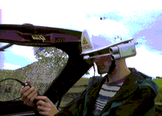
One room of the Farmhouse was filled with Pete & Wookey's computers containing a range of survey software. Wookey also brought an A0 plotter which had recently been salvaged from a CADD company's skip, to see if it worked OK. Chris Trayner brought his tiny desktop photocopier, which proved very handy for copying survey notes. Jan Jarvik from Imperial College CC brought their latest expedition scrounges: the MDL helmet-mounted Total Surveyor, and a snazzy laptop.
On Friday Night Rosy Rabson provided a welcome bucket of broth for all, and many went off to the pub before the traditional evening of music, beer (tinnies were on sale) and chat. Pete's audacious plan to survey as much of Lost John's in a day as possible was revealed and teams approximately sorted out, before retiring late to packed rooms.
The emphasis for the weekend was very much on practical surveying, with 8 teams of surveyors despatched to a pre-rigged Lost John's, each to survey a specified segment. This was a part of the massive Easegill re-survey project, making use of the manpower that the CSG can provide whilst taking the opportunity to teach some novices, and to learn from each other's methods.
I was part of three teams sent to the bottom. From Groundsheet Junction we each surveyed in a different direction - one upstream (Dave Ramsay, Andy Atkinson, and a chain-smoking computer salesman, who's name I have forgotten), one downstream (Wookey, Tanya Savage, and Jon Shaw), and one back up Valhalla & Battleaxe towards dome junction (Sam Lieberman, Anthony Day, +1). The cave had previously been equipped with tags at important junctions. These allowed the different groups to know where to join up. The Easegill project has found yellow plastic 'cow tags' (intended to be put through cow's ears and marked with an ID) to be very useful. A hole for one can be drilled by hand in 10 minutes or so. There is a little subtlety to this though, as we discovered: our first hole was just about completed when one side split off, making it useless. The disgruntled driller (Jon - on his first survey trip) started again at another spot, and having finished, put a cow tag into the hole, hammering it home, only for it to snap off, leaving the stud in the hole. Thus he got to spend another 5 minutes getting the dead stud out and (this time rather carefully) inserting another tag. So - note that they can be a bit brittle at cave temperatures if you ever have to put any in.
Water levels were very low, so the streamway survey was much less grim than I had expected, but it did go on rather. Both Tanya and Jon were new to surveying (Tanya had somehow managed to avoid any on three Austria expeditions), so we started off slowly explaining the techniques and pitfalls. Both got the hang of it quickly and were soon measuring off down the passage as fast as I could sketch. After about 2 hours, 24 stations and 220m we were a bit chilly and very bored, so we took a run down the passage to see how far we had to go. Depressing! It was some distance to the first inlet, some more to the next, and really quite a long way to where it got above MSBL in the Long Pool. That made it miles to the sump - we'd be here till halfway through Sunday to finish off the whole lot. We weren't very interested in missing the pub, so we carried on for another couple of hours until we reached the first inlet (from Rumbling Hole), with 46 legs. The upstream team had finished their bit before us, so the keen ones (Andy And Dave) came and started the next section from Rumbling Inlet to Mud Inlet, joined by Wookey after his assistants made their escape. After reaching Mud Inlet we set off out, only to catch the third team at the foot of the big Valhalla pitch (which is handily 30.00m to a convenient point!). It was clear that they needed a hand, so we went back up to the next cow tag (just beyond dome junction) and surveyed back down the small pitches to meet them. Then we all ran away for dinner & beer about 800m surveyed between us.
Meanwhile, in the entrance streamway, other novice surveyors, including several members of CREG, were being shown how to survey by Pete. Comments afterwards showed that they found the exercise interesting and useful - they had never fully appreciated the various problems of sighting, avoiding magnetics, lighting the instruments, and picking stations before. Soon they were up to speed, and completed the survey of the entrance passage.
Back at the farm, people experienced the excitement of typing their data into the computer, to get an instant plot for checking, ready for printing out and drawing up. A couple of blunders were spotted (upside down pitches sticking out of the ground - you know the kind of thing), and it also became clear that what we thought was the tag at Dome Junction, was in fact a tag about 100m further into the cave, so all the end surveys were hanging. We hadn't realised that the tags didn't necessarily have any survey attached to them. A couple of brave volunteers went down on Sunday to fill in the gap.
Another group of cavers wandered about doing a surface survey to connect various entrances (Lost John's, Short Drop, Gavel etc.). They also tried using a GPS but its nearly flat batteries precluded any useful comparisons being made.
Other things we had the chance to fiddle with were the new CSG instruments. These are Silva devices, bought with an NCA training grant, to be used for events such as this field meet. They are basically much like the Suunto instruments that most of you are familiar with, but are somewhat cheaper, and have several small differences. The most important is perhaps that the view though the eyepiece shows more of the dial than a Suunto, such that you can always see two 10's at once. With a Suunto when the reading is around 22 or 18, for example, you can see the 20 but not the 10 or the 30, which makes it easy to get these readings wrong. This should never happen with the Silvas. The only obvious disadvantage is that the eyepiece has a plastic collar extending around it, which makes the glass surface deeply inset - this will make it very difficult to get the mud out with a finger. As to durability we shall have to wait and see how they work out.
Wookey showed off the CUCC LED instrument lights, which include a few innovations since the design published in CP7 pp7-8, and a first go at a lanyard-mounted battery for a compass. Everyone was impressed with the brightness and neatness of the designs. The lanyard model survived the Lost John's Trip, so we'll see how it does on expo next. [An update on these lights after 2 years of refinement will be in CP soon - Ed]
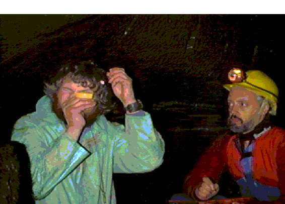
'Best toy of the meet' award went to the helmet-mounted total surveyor, without a doubt. This is the model mentioned in CP 16 pp3-4. The device (see Figure 2 - The MDL Helmet Surveyor) consists of a typical construction helmet with the optics mounted in a very solid aluminium box on one side, with a boom-mounted cross-hair that is positioned in front of one eye, making you look like one of the Borg. Moving this up and down swivels all the optics too. Finally there is a small box containing a fire button, an LCD display and the batteries, connected to the headset by about 0.8m of cable. You need to adjust the cross-hair to suit the size of your face, but once that is done the device is very quick and easy to use; you look at what you are interested in and push the button to activate the laser - once you are happy with the position you release the button to actually take the measurement. The device beeps after maybe 0.5s to say that it is ready and distance, bearing and inclination are displayed on the handheld unit. It's range is up to 250m (in daylight) and it doesn't need a target - Easy-peasy. Is this the ultimate surveying tool? And how well does it work underground? We took it to see.
As this is an extremely expensive piece of kit and we didn't want to break it before ICCC took it to Slovenia (and because we like an easy life), we took it into Yordas Cave for our trials. One thing we weren't quite sure about what whether the distance was measured from the cross-hair, the back of the hat (e.g. for standing with your back against a survey station) or some other datum. Our efforts to find out showed up some rather strange behaviour. We used a small piece of wood to give it a flat surface to read from, and a standard tape measure to check the distances with. For a 2.85m leg the zero seemed to be at the back of the helmet. For an 8m leg the zero appeared to be 10cm in front of the cross-hair, and for a 28m leg the zero was at the cross-hair. This was odd, but entirely repeatable and consistent. We eventually concluded that the zero-point was in fact the cross-hair (which made sense), but that the device gave inaccurate readings for short legs (less than about 10-15m), reading up to 40cm wrong. Checking the compass and clino readings was harder to do accurately, but so far as we could tell it always agreed on both to within 1 degree, which is pretty good. The clino readings apparently do not work well at angles steeper than 45 degrees, but this is not too serious.
In theory the underground range is significantly more than that above ground as it is easier to pick out the laser, although as you don't tend to get many 400m survey legs this is probably not very relevant. The helmet is clearly excellent for taking readings up avens and across pitches, but its apparent problems with lengths make it pretty useless for general surveying. Jan will ask the suppliers what they make of our test results. It is supposed to work down to a couple of metres, so it may be that there was a problem with the unit we were using. ICCC intend to remove the device from the helmet so that it can safely be taken caving and will report back on how they find it in actual use.
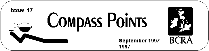
Pete's Canon Ion digital camera, which we used to take these pictures, probably got second prize in the gadgets competition, although Chris Trayner's baby photocopier was nearly as good.
With all the actual surveying that went on there wasn't much time for looking at survey software, beyond that necessary for inputting and checking the new data, however on Sunday afternoon we were able to try out the plotter. After a short false start wondering about configuring the serial interface we found that it had a parallel port, which made the connection trivial - just the same as a printer. A few minutes working out how to push the buttons to fire it up, how load a sheet of paper, and how to adjust the rollers for different sheet sizes and landscape/portrait were needed to get it to do a test plot, which showed that it was basically working fine. Digging a better pen out of the pile and adjusting the velocity and pressure to suit gave us pretty good plots, so we put in a sheet of A1 and plotted out the 3 counties system centreline to stick up on the wall. As ever, no-one could resist gathering around to watch the plotter plot, whizzing back forth making interesting noises. All very successful - definitely a top class scrounge!
Well we had a very successful field meeting at the home of the Red Rose Cave and Pothole Club. I think some members got a bit of a shock when they realised that we were actually going to do some surveying and not just sit around talking about it!!
A training workshop was carried out in the entrance series of Lost Johns and the newcomers seemed quite impressed to see their work on the screen back at the farm and Mark Stephens has even returned to the farm on subsequent weekends to help the Red Rose with the surveying in Ease Gill.
All in all we managed to get 30 people surveying over the weekend and achieved 1.72km of underground surveying and 1.75Km on the surface.
When all the data had been sorted and fed into the computers the 3D image was able to show the development of this system far more clearly than anything previously published on paper.
The work done over the weekend is already proving extremely useful as new exploration in the area is revealing new passage daily and the surveying is carrying on in this extremely interesting area of the Dales. It appears that there will be plenty to keep us occupied in the future as there seems to be a lot of passage awaiting discovery.
A big thank you to the members of the Red Rose who rigged and de-rigged the cave with bits of string! and all those who turned up to make the weekend a success.
If anyone would like to help with surveying in the Three Counties System I can be contacted at:
IVY COTTAGE,
RIVERSIDE,
CLAPHAM,
via LANCASTER,
LA2
8DS
Tel: 015242 51614 or e-mail: pag1@mail.cybase.co.uk
PS. Would anyone like to help organise the next weekend
in the autumn (Wales might be a good idea)?
Wookey
There were a number of events and lectures of interest
to surveyors at the Congress in Switzerland. Wookey, Olly Betts
and Andy Atkinson were there to represent the CSG. There was Symbols
discussion and ratification, Computing workshop on software and
drawing, demonstrations of Toporobot, Survex, WinKarst and others,
Map Generalisation, Surveying competition and a post-congress
surveying and computing workshop at Zwinglipass. Some of these
may generate future articles in their own right, but here is a
summary to keep you up to date.
The week-long Congress was based at La Chaux-de-Fonds in the Jura close to the French border of Switzerland. It was split into several symposia, the most interesting of which, to cave surveyors was 'Mapping and techniques'. There were numerous camps, workshops and events both before and after spread over a wide area from Italy to Poland. We went across to the other side of Switzerland to go surveying and to talk about survey data exchange formats.
The first morning started with demo's of cave surveying software. Jean-Pierre Cassou was supposed to be first off with Hades-2000, but he never made it to the conference, so I haven't seen that software. I understand it is a development of the 'VisuelTopo' which is quite popular PC software in France. Next up was Me (Wookey) talking about Survex, with Olly driving the computer. Slots were only 20 minutes so we could only give a quick overview of the software, it design and history, and showing how it works under both Windows 95/DOS and RISCOS.
Next was Martin Heller giving his Toporobot demo. This was very impressive, consisting of a set of slide images showing various images which had been made with the publicly available Limelight cave survey program and various other bits of software for digital elevation modelling and imaging. Some of the images were: An overview of Switzerland and its relief, all the karst sites in the country, a flight over the terrain, stretching a normal topo map over the terrain model showing the contours and rivers stretched into place, removing all the colour from a terrain model so as to clearly see the shape without distractions, adding mist to valleys to make them look convincing, showing a cave (Siebenhengst) inside the terrain model using a transparent area, the fractal bump mapping enhanced 3D cave models that Limelight produces, and flying around them. Most of these images are not possible without the expensive digital elevation data and software to manipulate it, but it was very impressive and showed what can already be achieved.
In the afternoon, as part of the 'Informal Session on Caves and Computers' Garry Petrie (pronounced Peetree, not petree by the way, we discovered) showed the latest version of WinKarst (v5.0). Details are elsewhere in this issue, but I particularly noted the speed improvements and the new triangular junction representation. The demo was optimistically given on NT, which he was trying for the first time, so it did blow up once .
Also in this session was Andreas Neumann, a student of Martin Heller. He showed us a number of things which he is currently working on. The first of these was a MacroMedia Director 'application' which gave you an impressive visual Karst information database for very little work. By combining a map of Switzerland (one of Martin's previous slides), with the existing Swiss Karst database it is a simple matter to plot the locations of the caves on the image according to criteria such as length, cave type, altitude, cave length etc. Zoom levels and links to the Toporobot surveys of the caves can also be added, although that bit is not yet complete. The effect is very similar to the program by Guy van Rentergem (see CP5, p8), but has the advantage of being easily moved to the web for general access, and required no real programming. Note that the Swiss database only outputs co-ordinates to the nearest 1km to stop people using this to find the caves.
Next Andreas showed us some of the work he has been doing on drawing caves with CorelDraw v7. He has been investigating the usefulness of this sort of software for drawing surveys given that it is about 1/20th the price of high-end CAD software like AutoCAD. In general he has found it to be satisfactory, and it is easier to learn to use than AutoCAD. He showed a couple of nifty things you can do. To get tick marks around a pitch edge he defined a new font containing ticks, and hollowed and filled triangles (These are used in Austrian surveys to indicate the size of the step and whether or not it is climbable). By using the 'fit text path to curve' function you can then just select the pitch-edge line and then type to fill it with tick marks (of varying type if required). Very neat. To get nice-looking boulders he used the 'calligraphy' feature. This varies the line width according to the angle of the lines, as does a wide-nibbed pen. You draw the boulder, then specify the angle to use. The effect is pleasing, and makes it look as if the boulder is lit from one side, emphasising its 3D-ness. Later I talked to him about some of the limitations I had found in CorelDraw 3 (see CP 13, p6), principally the problem of grouping across layers. He suggested that the 'ID' feature of the newer version could be used to keep all the parts of the picture associated across layers. I will investigate this solution when I can get hold of a newer version of CorelDraw.
Finally Andreas talked about Map Generalisation. This is the process of reducing the detail and drawing a representation, rather than the object, whilst still giving the right idea. One thing he had to work on was semi-automating the drawing of cliffs. He wrote some software which, once it is shown the outlines of the rocky area, will look at the direction of slope and add the intermediate downslope lines with appropriate weighting, to give a realistic effect. He has also worked on automating the drawing of rocks on scree slopes, with randomisation to give generally smaller rocks at the top, and larger ones at the bottom, without it looking artificial. Toporobot also has a generalisation feature which combines parallel passages, and removes unimportant ones when the cave is viewed from a long way off. This helps with speed of display, as well as helping the cave to continue to make sense as you zoom out.
In parallel with this session was the discussion of cave mapping symbols. There were representatives from the UK, Turkey, Austria, Switzerland, Australia, and France, plus maybe a couple more quiet ones. In general the discussion proceeded quickly without much dissent, although a few symbols caused some debate. Despite a general desire to distinguish between 'underneath' and 'wall position not clear/known', which are both currently dashed lines, no satisfactory other solution was found so they remain the same, although changes were agreed on the representation of leads (also dashed lines). Dotted lines were rejected as they already represent sand, tend to disappear on photo-reduction, and the symbol for 'hidden lines' in CAD is already a dashed, rather than dotted line. On computer-drawn maps a greyed line for underneath was suggested at the Surveying Workshop, and this may be adopted in the forthcoming session to further discuss symbols, which will include colour as part of its remit. If anyone would like to take part in these further discussions, please contact either me (Wookey), or Philipp Häuselmann. Roof steps also caused some discussion but we eventually agreed on the proposed symbol (like floor steps but dashed). The most acrimonious debate occurred on the subject of pitch/climb/aven depth indications. The Austrians insisted that this was a topographic survey, not a rigging guide and that it was not necessary to indicate the difference between a drop that needed gear and one that didn't - also this was a subjective decision. Nearly everyone else thought that it was a very important thing to indicate, subjective or not. The problem is that the current use of a letter e.g. 'p' for pitch and 'c' for climb (in the UK) does not translate well (the French use 'p' & 'e', with 'c' meaning aven, the Germans use 's' for pitch, the Turks use 'm', etc. Finding an international solution proved difficult. We thought about using a little crab or ladder symbol. Or a random letter like 'X', but all these were dismissed for one reason or another; the crab just looks like a G, it was thought that the ladder would be interpreted as 'fixed ladder in place', the X didn't really help, so eventually we decided to just have a number with no letter for a climbable drop, and a number preceded by a letter (varied by country, but 'p' recommended) for a pitch. Andy Atkinson sat in for the afternoon session whilst I went to the Caves & Computers workshop. He reported that the dated symbols (e.g. draught and snow) were changed to use ISO format (YYYY.MM.DD), and that a great deal of debate occurred for the stalagmite/stalactite symbols. Eventually they had two options; a little 'Y' or (on plans) a perfect circle, circle with dot or filled circle for stalactite, stalagmite and column. A few of the symbols were declared unnecessary, such as 'entrance pitch' and 'cuesta scarp line'. The complete list will be officially ratified by the UIS at the next meeting, and then will be published.
The was a survey competition, and a surveying competition. CUCC entered their latest Kaninchenhöhle survey in the 'long caves' section of the former. The other contenders in this section of the competition were Monsterhöhle (Austria) and Optimajestika (Ukraine). The Former was done using the atlas-system, where the cave is drawn on many separate sheets one for each 100m grid square, repeated if there are multiple levels of the cave overlapping in a square, with each level highlighted on one square. An overview of the plan and elevation is also provided. The Optimajestika survey was done on many carefully glued-together sheets in the ink-blob style familiar from the 'Northern Caves' guidebook series. It also had the main routes, campsites and water sources marked on in colour. The impressive thing about this survey (which is now just over 200km long), is that they don't have a computer, so the whole thing has been done with a pencil and protractor! If the loops don't close to the width of the pencil lead they just go and survey it again until it does! The judges thought that the Optimajestika survey was not really of good enough quality, so the choice was between the other two. CUCC's survey was commended for excellent draughtsmanship (by a professional!), and good spacing and clarity, but was let down by two blank areas with no grid ( a side effect of photo-reducing from 4 separate A0 sheets), and having 'too much labelling' (this is because it is actually drawn for exploration, rather than for map competitions, but is a fair criticism). Finally there was no elevation to accompany the plan ('cos we haven't drawn one yet ). Thus Monsterhöhle took the prize. The next day someone stole our survey and then came back an hour or so later for the 'highly commended' ribbon - bizarre; we can only really look upon it as a compliment!
Wookey & Andy were rather less successful in the surveying competition. The course was laid out in a grassed and wooded area, crossed by a road, outside the building - 14 stations, 120m. The points were pre-marked, and a string laid round the course so you could find the points. A brand-new Suunto compass/clino set was provided. We decided to have a decent go at it and did backsights throughout, averaging equally good sights, or taking the better/easier sight. The first leg had us stumped for a bit as no matter how hard we tried we couldn't get the fore & backsight to agree by better than 20 degrees. It was a few minutes before we realised that the supplied instruments were in grads - ie. 400 divisions rather than 360, so backsights were 200 off, rather than 180, which does make the sums a lot easier. We avoided the highly magnetic skip station, and the slightly magnetic 'plastic' rod, but when our numbers went in the computer we had the worst misclosure by a huge margin - the others were 10-30cms - ours was 2.3m. Peering at the numbers showed that somehow we had one leg about 100 degrees wrong. So much for backsights! Presumably I wrote down 300 instead of 200 - mutter. In disgust, we resolved never to play this game again, as we are always useless at it.
There were a couple of other talks which were vaguely relevant to Compass Points about karst databases. We had presentations from the Slovenian and German cave databases, and from Peter Matthews about the Australian Karst Index and the UIS database which it is based on.
After the congress the surveyors - Martin Heller, Yvo Wiedmann, Philipp Häuselmann, Andreas Neumann, Urs Sanderlich + 2 (Swiss), Wookey, Andy Atkinson, Olly Betts (UK), Nancy Pistole, Peter Haberlund, Garry Petrie (US), Jeff Butt (Australia) - drove to Zurich to spend the night, eat tea, and play with Martin's amazing collection of wooden puzzles. The next morning we played an amusing convoy game through the traffic lights of Zurich and then drove to Wildhaus, from where we went up by cable car, then walked whilst our bags travelled by car and then goods cable. We only had to carry all the gear & food the last 20 minutes up to the hut.
We were given an overview of the area & its geology, which has plenty of caving potential, and team keen went to do a bit of caving/surveying, whilst nearly everyone else went for a walk. Andy & I checked out a large cave entrance about 1km from the hut. Inside there is an ice lake that apparently only opened up a few years back, to reveal a 4km long cave that is mostly unsurveyed. We got as far as the icy blast coming out of a damp ice-slope before turning back (not very enticing in shorts and zoom). At one side of the ice-lake was a spit 5cm above the ice, with its hanger and crab entombed in ice - most odd!
There was plenty of talk in the evening, and the next day we got down to business. Most people went surveying to compare techniques, especially on vertical sections, whilst Martin, Wookey, Olly, Andy & Garry stayed in the sunshine to discuss data-exchange standards, and more fundamentally a complete cave data-model that could encompass existing survey data from the US, UK & European styles, as well as define future requirements such as a complete 3D arbitrary mesh, and intermediate concepts such as tubes & chambers. We started by working out a hierarchy of forms, and equivalencies such as the US/UK set of shots that form a survey, and the European concept of a series, which is a section of passage. We also looked at the pros and cons of a tagged data format and a table-based (i.e. relational database) format, coming down in favour of the more flexible database format. We were able to define the basis of a complete cave data model, which could be used for a program's internal representation, or a transfer standard. The details of this will be in a forthcoming article. The authors of Survex and Toporobot (Martin and Olly) agreed to look at ways of collaborating in future rather than producing competing applications.
Once the surveyors returned we were able to look at the various sketching styles. This was very interesting, with a wide variation in symbols, layout & style. Yvo impressed everyone with his in-cave sketch that looked a lot sexier than many people's finished surveys, although there was some doubt as to whether his light was better than Nancy's or if he was making up the walls at the ends of the rift somewhat. Yvo uses the technique, popular in mainland Europe of drawing in 'shape lines' on the elevation, which show the curvature of the shaft or passage. Sometimes similar lines show the geomorphology instead. Philipp had an example of this. We had a bit of an argument about their use of the 'ticked-line' symbol, normally found around pitch-heads in the UK. They used this symbol on the elevation to show a step, but the tick are on the wall closest, in this case, rather than on the one furthest away as when it is used on the floor. I thought that this was inconsistent, but they maintained that in fact this was a subtly different symbol, and that it 'looked right' like this, which I think is probably true. You have to think of the ticks as indicating the block structure of the wall.
We also discussed the relative merits of projected and extended elevations, and various ways of drawing awkward passages (ones with deep undercuts, both undercuts and overcuts, hading rifts etc.). It was noted on a survey that Philipp was using as an example he had avoided using the '-473m' notation, as he though it might one day connect with another cave that had a higher entrance. This would make all the depths wrong, so he used metres-above-sea-level instead.
We also looked at Jeff's surveys which had all been drawn on computer using Claris Draw. He had basically just treated the computer just like a piece of paper, but obviously it makes lettering and consistent line-widths much easier.
Philipp still did all his drawing on paper around a Toporobot skeleton, but he did use the computer to plot out all the names on a separate sheet which is taped behind the film that the survey is drawn on for final photocopying.
One other area of discussion was the way different groups have organised their survey data archives. Martin Heller has been running ht Swiss one for many years, with a policy of only making data available according to the wishes of those collecting the data. This has worked very well once trust was established, and there is now a central repository of nearly all the survey data in Switzerland. A similar scheme has been running for a shorter time in Haute-Savoie.
In conclusion I must say that the event was very well organised an very interesting. It was particularly good to put so many faces to names and email addresses, and I now have a very long list of invites to go caving around the world. Thoroughly recommended. The next one is in Brazil in 4 years time, so start saving up your holidays.
Wookey
As a member of the group you should be aware of the constitution. This is expected to be voted in at the forthcoming AGM.
Andrew Atkinson - 24 June 1996
Based on the CREG constitution by David Gibson, CREG Secretary, 9th April 96