
| Instrument Error Experiment at SWCC * | Mark Stephens |
Cover: Brian Clipstone doing the instrument experiment at SWCC
The CSG isn't a very big organisation, as we inhabit a fairly esoteric corner of the universe where surveying and speleology intersect. However the committee suspect that there are a number of people around the world who do surveying, and would like to know about what is going on, but who haven't yet realised we exist. We will be having a go at raising public awareness of the group over the next year which will hopefully result in a few more people joining, giving us a wider knowledge base and more cross-fertilisation of ideas. This will start with a general article in the national caving press about the CSG, and a press release to foreign caving journals. It would also be nice to contact some professional surveyors via their journals - does anyone have any suggestions about where would be a good place to publish?
One other thing - can I repeat my request for you to send in some examples of your surveying so we can publish them. It's important to see others' technique and methods, to learn from them.
New Webmaster. Your overworked committee has volunteered Andy Waddington to be the CSG webmaster. This is likely to result in much more timely updates to the CSG website, a general revamp to include more links to relevant information, and some progress on our long-standing plan to index Compass Points issues to make them a more useful research resource.
BCRA Regional Conference & CSG Field Meet - North Wales
We will be combining with this BCRA regional event, and CREG to hold a field meet this weekend. We'd like to meet surveyors from the area, will visit some caves on Sunday, and will be on hand on the Saturday to speak about and demonstrate the state of the art in cave survey software. You book for the CSG field meet separately from the BCRA regional conference. Contact Andy Atkinson if you want to come along. Accommodation details have not yet been finalised.
Royal International Eisteddfod Pavilion, Llangollen on Saturday 15th May 1998
Talks to include:-
- The geology of North Wales
- The mines of Anglesey and Snowdonia
- Finding voids the high tech way
- Pre-Roman copper mining
- Computers in surveying
Plentiful camping, bunk-houses, B&B and hotel accommodation in the immediate vicinity.
- Tea, coffee, beer and sandwiches available all day.
- The Cave Surveying Group will be on hand to demonstrate survey software, and will have copies to hand out.
- Trade stands.
- Field trips and visits will be organised for the Sunday.
The North Wales Caving Club are pleased to act as hosts to the BCRA for a regional conference in North Wales on Saturday 15th May 1998. The meeting will coincide with a CSG & CREG field meet.
North Wales is one of the least well-known caving areas in the UK, but has some significant caves and great potential. There are two main areas of Limestone (both Carboniferous) in North Wales - one runs south east from the coast at Llandudno to Ruthin, the other from Prestatyn to Oswestry.
There are very many small caves in North Wales, but the principal ones are found in the Alyn Valley near Loggerheads where Ogof Hesp Alyn extends for well over a mile.
Further to the south and east, on Esclusham Mountain, three separate sections of the extensive Ogof Llyn Parc system are accessed through mine workings; this cave is a SSSI.
The whole of North Wales has been extensively mined. Slate mines are common, most famously at Blaenau Ffestiniog, but there has been considerable extraction of lead and zinc, and there are pre-Roman copper mines on the Great Orme.
The opportunities for underground exploration in North Wales are almost unlimited.
Admission £2 in advance or £3 on the door,
cheques made payable to North Wales Caving Club. Tickets and more
information from Simon Dennis, Secretary NWCC, Kemmel, Storeton Lane,
Barnston, Wirral, L61 1BX (Tel: 0151 648 6578) or Adrian Farrel,
Ty Du, Abbey Road, Llangollen,
Denbighshire, LL20 8EB
(email: af@datcon.co.uk).
Cave Photography and Electronics Field Meeting, March 1998 - Yorkshire Dales
A joint field meeting organised by the Cave Radio & Electronics Group for cave photographers and cave radio & electronics enthusiasts will take place over the weekend of 28th/29th March 1998. The venue is near Clapham, North Yorkshire.
Practical sessions will take place underground on Saturday and Sunday. To a degree, the photographers and the radio enthusiasts will be engaged in separate activities, but we hope to be able to show some new electronic aids designed to assist in cave photography. Also, the photographers may like to use the radio experimenters as photographic subjects. A practical workshop on underground portraiture is being planned too. There will also be a programme of talks and slide shows on the Saturday evening including a session specifically for novice cave photographers. A fully equipped darkroom is available on site so you will be able to develop films taken on the Saturday.
And if you have anything that you think will interest others, please bring it along.
Accommodation for the nights of Friday 28th and Saturday 29th has been secured in a bunk barn on-site. This costs £10 per person per night but numbers are limited.
If you are going to attend, please get a booking from Mike Bedford at 4 Holme House, Oakworth, Keighley, West Yorkshire, BD22 0QY, as soon as possible - it's first come, first served!
Please let us know what you intend to do and any special requirements. I'll send details of how to find the accommodation and which caves we'll be using a couple of weeks prior to the event.
Autumn CSG field Meet
The CSG will be holding its first Derbyshire field meet on the weekend of the 17th/18th October based at the Orpheus Caving Hut.
We do not yet have specific plans for this meet, but all surveyors will be welcome, novice or experienced. Training will be provided for anyone who wants it, and we expect to visit a few interesting caves or mines in the area, perhaps to see some of the unique problems of mine surveying, such as magnetic ores. If anyone in the area has particular projects they would like help with, please make them known to the meet organisers.
There is accommodation for 18, although this may be shared with other visiting cavers. Cost is £3.00 per night unless you are a member.
The contact for this meet is Andy Atkinson (address on CSG Home Page).
In CP9 Wookey described the service provided by the British Geomagnetic Survey, for providing detailed magnetic variation information for the UK. The BGS have moved their web presence so the URLs given in that article are out of date. They have also improved the service to give declination directly, rather than you having to work it out from the X&Y components of the field.
http://www.nmh.ac.uk/ home page
http://www.nmh.ac.uk/gifs/on_line_gifs.html info page
http://www.nmh.ac.uk/gifs/hourly_means.html Information about the observatory hourly mean data
An example of the new data format is shown below
In the last issue we asked if anyone knew of survey software for Psion handheld computers. No one has come back to say yes, but I have now got hold of a C-compiler for the Psion5, which should allow us to compile Survex for it. There probably won't be any graphics without some work, and I don't know if it's any use for Psion 3-Series machines. More info next issue I hope.
I also note that Alistair Garman in his article about Psions in Descent 138 (Oct/Nov 1997) says 'and if no-one else does it before I next go overseas I'll write a very simple surveying program and make it available'. Might be worth finding out if he's been overseas again yet.
COMPASS
Larry Fish
I would like to announce a new release of the cave survey software package COMPASS. There are several major new features and lots of minor improvements.
1. Cave Database. COMPASS now has its own database program called CaveBase. CaveBase allows you to create your own databases of cave features. For example, you can keep track of the minerals, water, life forms, leads, chemistry, temperature, wind direction, rock type, stratigraphy, passage size, formation types, pH, etc.
Once you have created a database of cave features, CaveBase has its own specialised query builder that allows you select specific sets of data using sophisticated SQL query commands. The results of your queries can be immediately viewed as coloured symbols in the Viewer. If the features in your database have numerical values associated with them, the symbol's size can be used to reflect the magnitude of the value. You can also ask complicated questions about how different data items relate to each other. For example, you could look for combinations of items like life forms near water.
CaveBase can access any standard Windows database data including DBase, Paradox, FoxPro, InterBase, MS Access, and through ODBC many others. It can also create new databases without the necessity of purchasing a commercial database package. You can even incorporate photographs and drawings into the database to create a visual record of the features in a cave.
2. Blunder Location. COMPASS now has a new feature that makes it easy to locate mis-tied stations. The feature works by breaking a loop at each station. The untied end is then checked against every station in the cave, looking for a better connection. The program keeps a list of the best tie-ins. Just testing the new feature, I found a dozen obvious bad tie-ins in the Lechuguilla data set.
Using the new feature, obvious blunders jump out at you. For example, here are some real-world examples of mis-ties in the Lechuguilla data set:
| OLD TIE | NEW TIE | OLD ERROR | NEW ERROR |
|---|---|---|---|
| K6 | K6! | 174.64 ft. | 6.19 ft. |
| ECKJ11 | ECKJ'11 | 152.78 ft. | 1.75 ft. |
| BNM4 | DNM4 | 127.52 ft. | 3.44 ft. |
| EY52a | EY52A | 87.47 ft. | 5.39 ft. |
Look at the second item in the list. It has 152 foot loop error. If the shot to EKCJ11 is reconnected to EKCJ'11 the loop error goes down to 1.75 feet, a dramatic improvement! It is obvious that the similarity between EKCJ'11 and EKCJ11 has caused this error. As you can see, all of these mis-ties are due to obvious typographical or clerical errors. The program makes it easy to find this type of error.
3. Viewer. The Viewer now has the ability to tilt the Colour By Depth and Depth Exclusion options. This makes it possible to colour or clip specific levels in a cave that has been tilted. The tilt can be set by specifying the azimuth and inclination of the tilt. It can also be set visually by dragging the arms of a three-dimensional "compass" into the proper position. The program even has the capability of analysing the cave and finding the average dip and angle of the passages.
4. Cave Editor. By popular demand, I have changed the survey selection process so a single click on the survey list selects the survey and a double click edits the survey. Also, the survey list now shows the date and can be sorted by date order as well as survey and alphabetical order.
5. The Viewer also has many other enhancements. For example, there are improvements to the colour-by-depth and colour-by-date options, which allow the thickness of each band to be set without setting the top or bottom.
Also, you can add your own programs and 'tools' to the Viewer menu bar.
One of the most important improvements is that the Viewer is now a DDE server. This means that it can accept data from external programs and incorporate them into the survey data. This means that programs like databases, spread sheets and word processors can now deliver data to the Viewer. Finally, the Viewer can now save the plot data to a new plot file. This allows you to save the query information that you have sent to the Viewer.
6. There are also many other bug fixes including several Windows 95 related problems which caused weird display behaviour like large lines appear, large text appears, and part of the image is lost.
7. Also, please note, there is a new COMPASS web page address.
HOW TO GET COMPASS
COMPASS is a shareware product. You can try it out free. If you like it and want to use it, you must register. If you don't like it, then don't use it and pay nothing.
COMPASS is available free of charge for evaluation purposes. Copies are available through the COMPASS World Wide Web page at:
http://members.iex.net/~lfish/compass.html
Survex v0.72
Wookey
There has been a minor update release of Survex to remove the annoying 'expiry date' messages of Survex versions up to now. As the rate of development of Survex has now slowed significantly, these are no longer appropriate. New versions of Survex for RISCOS, DOS and UNIX should all be on the Survex Website by the time you get this.
Wookey
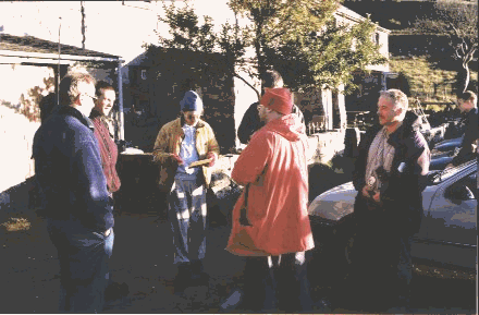 The CSG held a field meet at SWCC, South Wales on 22nd/23rd
November. We did some interesting practical experiments on Differential GPS
and instrument calibration.
The CSG held a field meet at SWCC, South Wales on 22nd/23rd
November. We did some interesting practical experiments on Differential GPS
and instrument calibration.
CSG members discuss the results
Present
This event was arranged at rather short notice after the BCRA conference so it fell between issues of Compass Points and thus was not well-advertised. This probably had an impact on the numbers attending so it was a relatively select meeting. Those present were Allan Richardson (meet organiser), Andy Atkinson, Brian Clipstone, Iain Miller, Mark Stephens, Wookey, and Malcolm Craik.
The SWCC library was centre of operations for the weekend and quickly filled up with computers. There was already the library machine, and Wookey, Iain and Andy all brought machines too. Due to the SWCC kitchen refurbishment, the kitchen was a rather smaller and more 'temporary' than usual, but as the cottage wasn't particularly busy this weekend it just made it more homely. The evening fireside beer complete with drunken guitarist was up to the fine standards we expect of SWCC, and made us all feel most at home. The weather was also kind, and it remained sunny, if a bit chilly, for our outdoor tests.
We did two experiments:
Experiment 1
The first was to take many readings with multiple people and multiple instruments around an approximately circular set of fixed points, to see how they varied with direction, person and instrument. This is something I have wanted to do for a long time to see whether the standard calibration correction (a simple offset from one reading to the others on a survey) was valid. This should show whether a person/instrument combination has a constant offset from the 'true' reading or not. It seems likely that this holds for eyesight-induced errors and zero-offset errors in the instrument, but not for external magnetic effects (which will sometimes be +ve and sometimes -ve depending on the orientation of the caver with respect to the earth's magnetic field.
Brian set out a course before we got there using a tripod-mounted accurate compass and put in permanent wooden marker stakes. All the attendees had at least one go round the course; most had several goes with different instrument sets. The data were entered that evening and Mark Stephens presents the results below
Experiment 2
Iain Miller has been doing work on cheap differential GPS using two Garmin GPS45 units. As this was the CSG, the 6 attendees had 5 GPS units between them (!), so we took the opportunity do to get some more data. 5 GPS's (4 GPS45's and one GPS12XL) were left on a permanent station on a nearby hilltop for an hour or so, whilst one unit with an aerial extension was left at another permanent station at the SWCC cottage.
The logged results were then compared to see how consistent the various units were, and whether using the base station to offset the results from the others improved the accuracy or not. Iain Miller will be giving the results of this, and other tests done on expedition in the next issue of CP. The executive summary is that it does work, apparently contradicting Bob Thrun's tests in CP12, and by examining the plots it is also possible to determine when the correlation is poor and the results will not be improved by offsetting one device against the other.
Mark was genuinely keen to do actual caving, so everyone whipped out their emergency excuse: "I've got to write Compass Points" (Wookey), "I've got to look after these children" (Allan), "I've not brought any gear" (Andy and Iain and Malcolm). This left Brian, who didn't seem to have one, so he took Mark on a look round the upper realms of OFD2.
So, another successful meet with some interesting results. We would be pleased to see some more CSG members at the forthcoming North Wales and Derbyshire meets this year.
All photos in this issue are copyright © Mark Stephens, 1997.
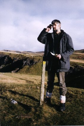
Instrument Error Experiment at SWCC
Mark Stephens
At the CSG 1997 November field meet at SWCC an experiment to attempt to assess various forms of instrument error was undertaken. Here Mark Stephens describes the experiment and the results.
Introduction
Software such as Survex has relieved us of much of the work in processing the raw data collected during a survey. We can now afford the privilege of being more sceptical about the quality of the information that is used in drawing the maps. Computerisation also allows the deployment of statistical tools to make the best use of the information we collect. Lest what we produce be merely lies, damned lies or even worse, we must apply these tools selectively, using only those that will extract the most truth from the raw data.
It would be ideal if a survey could by placed on top of and to the side of the cave being mapped in order to test its veracity. More realistically, the position of any parts of the cave reaching the surface can be compared against a surface survey using theodolites. These are external quality checks. Internal quality checks can be applied more quickly and cheaply with loop closure being the prime example. Several legs of a survey that proceed down a series of passages to return to a point by a different way from which it was left form a loop. The end-point of this loop should be equivalent to the starting point of the loop, as they are the same point in reality. Errors of measurement in each leg will combine and the end-point of the loop as drawn will not match the start point. Survex will minimise this difference between the start and end points by adjusting the position of the intermediate points. The algorithms used are intended to deal with random error, and may not give correct results for systematic errors.
Motivation
The key assumption being made is that there are no systematic errors, yet potential sources of such errors are well known. The most common sources include the misalignment of the magnetisation of the compass and the presence of extraneous fields from steel watches and caving paraphernalia. Other sources of error could include an unconscious preference by the surveyor to round down rather than up, or to read values most like the last recorded value. These errors are not systematic as they would not be repeatable between measurements, but they are not evenly distributed either side of the true value which is a prerequisite of the valid application of least squares analysis.
It must be believed that all of these sources of errors exist. What is worth discovering is which kinds of errors occur in sufficient magnitude that it is worth undertaking effort to eliminate them or at least ameliorate there effects.
Experiment
Four compasses, four clinometers, one precision compass and seven people measured out a small course laid out on open ground adjacent to the South Wales Caving Club's cottages at Penwyllt, Pen-Y-Cae, Swansea. Various combinations of people and instruments toured the course in an attempt to provide sufficient data to separate the errors due to the instruments from those peculiar to individuals.
Weather
Visibility was perfect, as the day was bright without fog or rain. It was however quite cold in a way that chilled fingers and precluded any dallying out on the course. Measurements were often taken quickly so that moving onto the next station would allow the limbs to generate some warmth. This effect could be described as typical of a caving situation.
Survey course
A wooden stake with its top distinguished by a splash of bright green paint was placed on a small mound some 20 metres from the end of the row of cottages. Ten more stakes, similarly painted, were fairly evenly distributed around at distances between 10m and 50m.
Figure 1 illustrates the directions in which the stakes surrounded the central one. The first bearing was taken from the stake at 215.6° towards the central stake and the course followed clockwise. The ground varied little in height apart from the east side of the course where the stake at a bearing of 87.4° was in a depression and the succeeding stake some 6m higher.
Precise instrument
The precision compass was a device brought along by Brian Clipstone. It was a tripod-mounted device with a sighting telescope and a spirit level. It was calibrated and believed to be accurate and precise to 0.1°.
Normal instruments
The four compass & clinometer sets came from the following sources:
These standard Suunto caving instruments are expected to be accurate to 0.5° when used with care. No calibration information was recorded for these devices and so the precision is unknown.
People
A mixture of experienced and novice surveyors took part, not from any plan but simply because these were the people there.
| Name | Experience |
|---|---|
| Alan Richardson | Experienced |
| Brian Clipstone | Experienced |
| Wookey | Experienced |
| Iain Miller | Experienced |
| Malcolm Craik | Novice |
| Andrew Atkinson | Experienced |
| Mark Stephens | Novice |
Process: what should happen
The intention was to produce a large set of measurements from each surveyor measuring the course using a different set of instruments each time until all the instruments had been used by all the surveyors. Each measurement should be isolated so that the result is not influenced by another measurement, the perceptions and prejudices of the surveyor, or other obviously avoidable disturbing sources. A baseline set of measurements provided by the precise compass was to provide a reference against which the common instruments could be judged. The errors in the baseline are to be insignificant compared to any others in the experiment.
Practice: what did happen
Human factors were clearly difficult to control. Two surveyors (MC/AR) went around as a pair, probably because one was teaching the other how to survey. One group of measurements was taken by a surveyor (W) carrying all four sets of instruments. These to be used together in one circuit of the course in order to test quickly a theory of whether using only one eye in the measurements would make a difference. In these cases once a measurement was taken, the remembered result is liable to influence the succeeding measurement. One surveyor (MS) stepped straight out of a car after a four-hour car journey to start the course. This may have had a detrimental effect on the quality of measurements, however this along with any hangovers suffered by the others may be regarded as natural hazards in caving.
Many of the measurements were taken by using a set of instruments to do a complete circuit and then changing the instruments to do another, until four circuits had been done and all the available instruments had been used. Instruments were changed over by swapping sets with anyone else who had recently completed. This should have randomly distributed the order in which the instruments were used but the degree to which the order of use was randomly distributed was unquantified. The same course was repeatedly used which meant the measurements would be comparable but a degree of improvement through practice could creep in, one reason why randomisation in the order of using instruments would be important. Some surveyors did not complete the course with all sets of instruments leaving gaps in the measurement records. Some attempt was made by surveyors to obscure the results of previous circuits by folding the paper the results were recorded on but this may not have been sufficiently successful.
The clinometers were not used when it was quickly realised that double the number of measurements would result increasing the time taken to perform the experiment. Why the clinometer was discarded rather than the compass may be to do with the authoritative aura that the magic of geomagnetism brings. In hindsight, this may have been a mistake as the clinometer has the same sighting mechanism as the compass yet does not have the additional external influences that could disturb a compass. A useful comparison may otherwise have been possible. The first stake could have been particularly prone to extraneous magnetic fields as it was sited close to a metal garage and several parked cars.
The baseline measurement was made by one person (BC). There is no reason to believe these measurements were flawed as they were taken by someone experienced in the usage of this precision compass. However, good scientific practise requires that any human influence here should also be eliminated.
Results
Pre-processing
The various scraps of paper used to record the bearings were read and the numbers were entered into a spreadsheet program on a computer. As measurements were entered, they could be compared with expectations and similar measurements. Gross errors such as reading from the wrong scale on the compass could be eliminated at this stage, as this would be normal practice anyway. No adjustment for declination was made.
All compared to precise
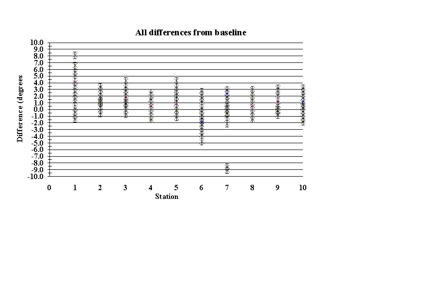
There is clearly a wide range of measurements, which are well spread out. The expected precision of 0.5° from a single measurement with a surveying compass seems to be wildly optimistic given the variation observed here. The apparent overall positive offset of the measurements from the baseline is unexplained.
Average of all compared to precise
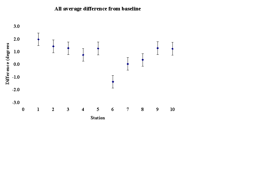
All the measurements for each station involving all instruments and all people were averaged and the difference from the baseline was calculated. The error bars are 0.5° (expected instrument error) and clearly show the relatively large deviations from the baseline. Station 6 seems to be anomalous. Likely possibilities are large buried metal at station 6, or that the reference measurement is wrong for this station.
Differences by instrument
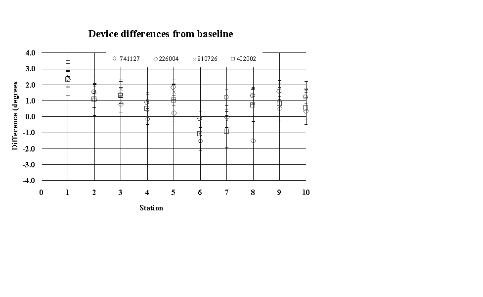
The measurements taken by each instrument are averaged over the surveyors that used it. The differences between devices are small and inconsistent.
Differences by surveyor
The surveyors have the measurements they take with the different instruments averaged to give a bearing for that station, which should be independent of the instrument, used. The amount this differs from the baseline provided by the precision compass is plotted. The surveyors appear to be much more unreliable than the instruments but the fact that the numbers are averaged over fewer samples could account for the wider variation observed here.
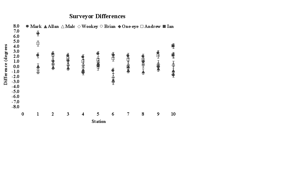
The surveyor called One-eye is Wookey trying out a different approach to using the compass. The effect of this does not appear to be significant.
Correlations
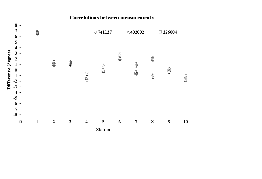
The following graph shows the measurements taken by Wookey when he took several readings at a time rather than trying to operate the instruments independently. Despite the magnitude of the differences from the baseline the readings vary little between themselves.
Conclusions
No attempt has been made to test the statistical significance of the variations from the baseline. The wide spread of the data is probably significant in that it shows that the errors in many measurements taken by typical surveyors are much more than the often-quoted 0.5° precision of the instrument used.
Further work
This article does not attempt to analyse the results much. There is significant potential to look at this data further to extract trends, and to work out how further experiments can be done to clarify the remaining questions. The experiment if repeated needs careful planning and orchestrating to eliminate the crude human foibles that could mask real trends in the data. A more thorough statistical analysis of the data from this experiment could at least be done as practise in anticipation of further experiments. Next time the CSG visits South Wales, we can do this experiment again, using the experience of this first test to be more rigorous and get a good dataset to determine the relative importance and consistency of the variations caused by people, instruments, techniques and equipment.
The Excel spreadsheet containing the original measurements and the derived results is available on the Compass Points website. Anyone who wishes to examine this data in more detail is most welcome to download it and have a look.
Here is the magnetic data downloaded from the BSG site for the period of the experiment. The important column for us is the Declination (D) in degrees. As you can see it varied by about 0.1 degrees over this period, which is pretty insignificant in comparison to the other results.
Hartland Observatory

Day Date     Hr  Hourly Means

                 D     H     I      X     Y     Z     F

326 22-11-97 10 -5.200 19496 66.090 19416 -1767 43974 48102

326 22-11-97 11 -5.220 19482 66.105 19401 -1773 43975 48097

326 22-11-97 12 -5.257 19428 66.166 19347 -1780 43980 48080

326 22-11-97 13 -5.251 19448 66.150 19367 -1780 43991 48098

326 22-11-97 14 -5.287 19439 66.164 19356 -1791 43999 48102

326 22-11-97 15 -5.218 19414 66.199 19334 -1765 44016 48108

326 22-11-97 16 -5.147 19447 66.164 19369 -1745 44018 48122

326 22-11-97 17 -5.167 19460 66.144 19381 -1752 44005 48116
Values of declination (D), inclination (I), horizontal intensity (H) and total intensity (F) have been included, on-line, as well as the values of the north component (X), the east component (Y) and vertical intensity (Z), which were the three components of the earth's magnetic field originally available.
The units of declination and inclination are degrees. Declination is negative when west of true north.
Inclination is positive in the downwards direction. The units of horizontal intensity, the north component, the east component, vertical intensity and total intensity are nT. Vertical intensity is positive in the downwards direction.
Compass Points INDEX
Cave Surveying Group Home Page